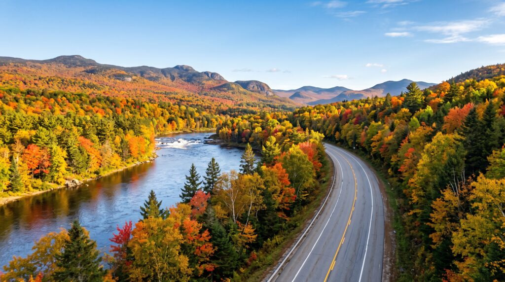
Leaf peeping forests stretch past towering ridgelines. Rolling rivers trace paths carved through centuries of wilderness lore. The Old Canada Road National Scenic Byway is an unforgettable route through this breathtaking landscape.
Few drives deliver wild beauty quite like Maine Route 201.
The Old Canada Road National Scenic Byway spans 78 miles through Somerset County. It begins at Robbins Hill in Solon and climbs straight to the Canadian border in Sandy Bay Township.
Travelers often call this scenic stretch the OCR. Along the drive, you will encounter rushing river rapids, quiet ponds, and welcoming mountain towns.
Grab your hiking gear and load up the car. This guide delivers everything you need for an unforgettable excursion through western Maine.
At a Glance: Old Canada Road Byway
-
Designation: National Scenic Byway (2000)
-
Intrinsic Qualities: Scenic
-
Location: Somerset County, Maine (ME)
-
Length: 78 miles (126 km)
-
Southern Starting Point: Robbins Hill Scenic Overlook in Solon
-
Northern Endpoint: Canadian Border in Sandy Bay Township
Visitor & Regional Contacts
-
Old Canada Road Scenic Byway Org: 207-399-6330
-
Maine Department of Transportation: 207-624-3300
-
Visit Maine State Tourism: 888-624-6345
-
Kennebec Valley Tourism Council: 207-557-0939
-
The Forks Area Chamber of Commerce: 207-663-2121
-
Jackman Moose River Region Chamber of Commerce: 207-668-4171
The Story of the Byway: Echoes of Maine History
Centuries ago, Indigenous Abenaki hunters traveled along these natural waterways. They paddled canoes across the Dead, Moose, and Kennebec Rivers to reach Merrymeeting Bay. These routes effectively connected the St. Lawrence River to the coast of Maine.
Later, Massachusetts leaders funded the Canada Road to link regional farms with Quebec City. During the late 1800s, this passage welcomed thousands of French-Canadian and Irish settlers. These hardworking families settled down and fueled the booming paper mills of the Industrial Revolution.
Military leaders also wrote history along this riverway. In 1775, Colonel Benedict Arnold marched his troops north along the Kennebec River toward Quebec City.
During the logging boom, timber barons dominated these lands. Legend says they even wagered entire 36,000-acre townships during late-night card games.
Lumber crews spent freezing winters in deep woods logging camps. Next, they rode massive log drives downriver on the spring freshet. You can still read their stories on interpretive panels stationed along the highway.
High-Octane Water Adventures
Swift river currents define this northern passage. The southern half follows the eastern shore of the Kennebec River and Wyman Lake. Further north, you arrive at The Forks, where the Dead and Kennebec Rivers meet.
Controlled dam releases make this junction a top whitewater rafting destination. Outfitters like Northern Outdoors and Three Rivers Whitewater lead thrilling trips through Kennebec Gorge. Trips range from gentle floats to roaring Class IV whitewater.
Calmer waters also beckon nearby. For instance, anglers can cast for native brook trout and landlocked salmon on Parlin Pond.
Waterfall lovers will want to visit Moxie Falls. The cataract drops 92 feet into a shaded forest gorge. An easy 1-mile trail brings hikers to multiple viewing platforms.
Additionally, Cold Stream Falls drops 30 feet into clear pools via an accessible 1.2-mile side trail.
Scenic Overlooks and Picnic Stops
Several roadside overlooks provide panoramic photo spots along the highway.
-
Robbins Hill Scenic Overlook (Solon): This location marks the southern start of the byway. Gentle crushed-stone paths wind past apple trees and native grasses. The vista opens to wide views across the Kennebec Valley and western High Peaks.
-
Attean Overlook (Jackman): Just south of Jackman, this overlook showcases the pristine Moose River Valley. Travelers enjoy sweeping views of Attean Pond and ridges trailing into Canada.
-
Northern Roadside Waterfall Rest Area: Further north near Sandy Bay Township, an interpretive rest area provides views of a rushing roadside waterfall alongside picnic tables.
Hiking, Biking, and Trail Adventures
Whatever the season, Route 201 offers fantastic trail access.
-
Pleasant Pond Mountain (2,447 ft): This popular section of the Appalachian Trail rewards hikers with full 360-degree summit views. Choose between a steeper 1.6-mile western trail or a gentler 5-mile eastern climb.
-
Forks Area Scenic Trail (FAST): Walkers, runners, and cyclists enjoy this scenic multi-use path system. Recent infrastructure enhancements expand fully accessible connections and portage facilities along the Kennebec River corridor.
-
Dead River Trail: This wide gravel path borders the rapids just north of the confluence. The 2-mile section offers accessible walking paths alongside picnic tables and fire rings.
-
Coburn Mountain (3,499 ft): Located between The Forks and Jackman, this rugged summit features the highest motor-accessible radio tower lookout in Maine.
-
Moxie Mountain: Accessible from Heald Pond Road, this southern trail ascends through spruce woods to a rocky crest.
Four Seasons on the Old Canada Road
Every season brings a fresh perspective to Route 201.
Spring snowmelt triggers rushing waterfalls and early-season whitewater runs.
Summer brings long days for swimming, lake kayaking, and hiking deep mountain trails. Wild blueberries ripen along sunny ledges across the high country.
Autumn creates a striking show along the corridor. Hardwood forests turn bright orange, red, and yellow against dark green spruce trees. Leaf colors typically peak between late September and early October.
Winter transforms Jackman and The Forks into a major snowmobile paradise. Interconnected ITS trail systems link riders directly to hundreds of miles of groomed wilderness trails.
Rest, Refuel, and Local Hospitality
After a full day on the trail, local hospitality gives you room to recharge.
Stay at Northern Outdoors in The Forks. You can rent log cabins and enjoy fresh meals alongside craft beer at Kennebec River Brewery.
Just up the road, Inn by the River offers comfortable rooms and scenic dining right along the Kennebec River.
Near the border, Jackman provides rustic sporting camps, classic roadside motels, and lakeside cottages.
Enjoy dinner, step outside to hear loons calling on the water, and wake up early to spot a moose feeding in the roadside bogs.
Historic Points of Interest
Take time to explore these notable landmarks along your drive:
-
Solon Meeting House (1842): Listed on the National Register of Historic Places. The building preserves its original podium, pews, choir loft, windows, and steeple. Community artists hand-painted remarkable fresco murals inside during the 1950s.
-
Bingham Free Meetinghouse (1835-1836): Located on South Main Street in Bingham. This structure was the first church built north of Caratunk Falls in northwestern Maine. Its design combines Federal and Gothic Revival features.
-
Wyman Dam (Moscow): Built in 1930, this NextEra Energy hydroelectric facility stands 155 feet high and spans 3,054 feet across the river. It created the vast Wyman Lake recreation basin.
-
Caratunk Falls Archeological District (Solon): State archaeologists documented this 16-acre site in the 1960s and 1980s. The ground preserves evidence of ancient human activity dating from the Archaic era through European contact. It joined the National Register of Historic Places in 1986.
-
Jackman Armand Pomerleau Park: This municipal green space rests at 1,180 feet elevation and offers a clean picnic rest stop right in town.
-
Jackman Historical Society: The museum highlights regional logging history, local photographs, and cultural artifacts from the Moose River Valley.
-
Sandy Bay Canadian Border Crossing: This international crossing marks the northern conclusion of the Old Canada Road Byway.
The Two-Peak Day Hike Itinerary
Try this memorable day trip to hike two scenic summits along Route 201.
-
Morning: Moxie Mountain
-
Start in Solon near Lakewood on Route 201.
-
Head north to Caratunk and turn down Heald Pond Road.
-
Pick up the southern trail along an overgrown logging path.
-
Follow the blue tags and stone cairns as the trail climbs steeply.
-
At 1.2 miles, pass the scenic outlook spur.
-
Bear right at the Deer Bog junction to reach the rocky summit in 0.4 miles.
-
-
Lunch in The Forks
-
Head down the mountain into The Forks for a warm lunch along the river.
-
Rest up and hydrate before your afternoon hike.
-
-
Afternoon: Boundary Ridge Hike
-
Drive north along Route 201 through Jackman toward the border.
-
Hike through mossy evergreen woods to reach the 2,630-foot open ledges.
-
Enjoy expansive views of Mount Abraham, Sugarloaf, Bigelow, and Mount Katahdin.
-
Whether you visit for a weekend drive or an extended outdoor vacation, Route 201 provides an authentic taste of northern Maine. Check your fuel gauge, keep a sharp eye out for wildlife, and enjoy the open road.
Table of Contents