
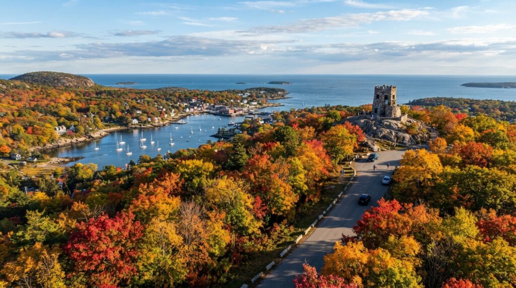
Autumn transforms Maine into an extraordinary landscape of scarlet maples, golden birches, and deep green conifers. As peak summer travel winds down, crisp air and clear skies set the stage for outdoor adventures. If you’re planning a Maine fall foliage road trip, you’ll find vibrant foliage drives, peaceful backcountry trails, and coastal stone fortresses among Maine’s public properties.
The state manages these recreation lands under three primary designations: State Parks, State Historic Sites, and Public Reserved Lands. Each category offers different access policies, facilities, and seasonal guidelines. Furthermore, understanding how Maine public lands operate in 2026 ensures your autumn road trip runs smoothly.
2026 Maine Fall Foliage: Regional Peak Windows
Foliage color advances from north to south across Maine. In addition, elevation plays a major role in when leaves turn.
+---------------------------+----------------------------+--------------------------------------------+
| Region                    | Typical Peak Window        | Standout Destinations                      |
+---------------------------+----------------------------+--------------------------------------------+
| Northern & Mountain Zones | Late Sept – Early Oct      | Deboullie, Bigelow Preserve, Grafton Notch |
| Central & Lakes Region    | Early Oct – Mid-Oct        | Mt. Blue, Lily Bay, Sebago Lake            |
| Midcoast & Downeast       | Mid-Oct – Late Oct         | Camden Hills, Cutler Coast, Fort Knox      |
| Southern Coast            | Mid-Oct – Late Oct         | Bradbury Mountain, Ferry Beach, Two Lights |
+---------------------------+----------------------------+--------------------------------------------+
Northern ridges and high-elevation western summits change first. Consequently, high peaks reach their peak foliage by late September. Meanwhile, the Atlantic Ocean retains warmth longer into autumn. Therefore, coastal foliage typically stretches into late October. Plan your driving route to follow this natural rhythm.
How Maine Public Lands Operate in Autumn
Understanding land management categories helps you select the right destination for your travel style:
+------------------------+---------------------------------------+--------------------------------------+
| Land Designation       | Autumn Character                      | Fall Amenities & Operations          |
+------------------------+---------------------------------------+--------------------------------------+
| State Parks            | Maintained trails, scenic foliage     | Restrooms, day-use entry, gated walk |
| State Historic Sites   | Dramatic forts, heritage landscapes   | Walking paths, exterior grounds      |
| Public Reserved Lands  | Remote backcountry, working forest    | Primitive camping, shared-use roads  |
+------------------------+---------------------------------------+--------------------------------------+
1. State Parks
Maine’s State Parks offer formal infrastructure. Most parks provide paved parking areas, picnic tables, and restroom facilities. Several locations also feature hot showers and dumping stations.
However, many park campgrounds close for the season around mid-October. For 2026, state park campsites switch to a first-come, first-served basis starting mid-September, with campgrounds closing on October 15.
When vehicle gates close for late fall and winter, visitors may still enter. Specifically, you can park outside closed gates and explore the trails on foot. For current pass rates and updates, check the Maine Bureau of Parks and Lands.
2. State Historic Sites
Maine’s State Historic Sites spotlight cultural heritage and military history. Coastal stone garrisons and archaeological grounds look striking against bright autumn trees. While interior museums and exhibits close after Indigenous Peoples’ Day, walking grounds remain open during daylight hours.
3. Public Reserved Lands
Maine’s Public Reserved Lands encompass more than half a million acres across the state. Unlike manicured state parks, these working forests emphasize multi-use recreation and wildlife conservation.
Public Reserved Lands do not feature formal picnic pavilions or modern bathhouses. Instead, visitors find primitive campsites, remote ponds, and quiet trails. Informal picnicking without open fires is permitted throughout these parcels.
Standout Public Reserved Lands for Autumn Hikes
If you prefer uncrowded destinations and rugged trails, explore these public parcels:
+---------------------+---------------------+---------+----------------------------------------------+
| Public Parcel       | County Location     | Acreage | Key Fall Highlights                          |
+---------------------+---------------------+---------+----------------------------------------------+
| Bigelow Preserve    | Somerset & Franklin | 36,700  | High-altitude ridgelines, Flagstaff Lake     |
| Nahmakanta          | Piscataquis         | 42,818  | Backcountry trails, quiet forest ponds       |
| Cutler Coast        | Washington          | 12,170  | Coastal headlands, colorful maritime bogs    |
| Deboullie           | Aroostook           | 21,871  | Fire tower outlooks, deep glacial ponds      |
| Mahoosucs           | Oxford              | 27,253  | Steep alpine passes, rugged Appalachian trail|
| Donnell Pond        | Hancock             | 14,496  | Mountain summit views, clear water beaches   |
+---------------------+---------------------+---------+----------------------------------------------+
Bigelow Preserve
-
Location: Somerset & Franklin Counties
-
Size: 36,700 acres
-
Activities: Hiking, primitive camping, fishing
The Bigelow Preserve holds the prominent summits of the Bigelow Range. The Appalachian Trail crosses Avery Peak and West Peak, offering expansive views over Flagstaff Lake. Backcountry campsites sit along the shorelines and lower trails.
Nahmakanta
-
Location: Piscataquis County
-
Size: 42,818 acres
-
Activities: Backcountry hiking, camping, fishing
Nahmakanta is one of the largest single units in the public land system. Located in Maine’s 100-Mile Wilderness, it features remote ponds and rolling hardwood ridges. Hikers can explore quiet loop trails without the summer crowds.
Cutler Coast
-
Location: Washington County
-
Size: 12,170 acres
-
Activities: Ocean cliff hiking, wilderness camping
Cutler Coast sits along the bold shoreline of Downeast Maine. Hikers cross maritime forests and peat bogs before reaching high cliffs overlooking the Bay of Fundy. In autumn, blueberry barrens and peat bogs turn a rich rust-red.
Deboullie
-
Location: Aroostook County
-
Size: 21,871 acres
-
Activities: Hiking, fishing, scenic backroads
Deboullie is located in northern Aroostook County. The parcel features rugged hills surrounding pristine glacial lakes. Anglers target native brook trout, while hikers climb fire tower trails for sweeping views reaching the northern border.
Other Notable Public Parcels
-
Holeb (Somerset County, 19,651 acres): Famous for the Moose River Bow Trip and quiet water access.
-
Mahoosucs (Oxford County, 27,253 acres): Covers steep terrain near Grafton Notch, including challenging alpine trails.
-
Donnell Pond (Hancock County, 14,496 acres): Features hiking routes over Schoodic Mountain with clear coastal views.
-
Dodge Point (Lincoln County, 506 acres): Offers easy walking paths along the Damariscotta River under beech and oak canopies.
-
Little Moose (Piscataquis County, 15,047 acres): Features forested paths and quiet waters west of Greenville.
Top State Parks for Fall Foliage
State parks offer convenient access and well-maintained trail systems:
+---------------------+-------------------+---------+----------------------------------------------+
| State Park          | Town / Location   | Acreage | Autumn Highlights                            |
+---------------------+-------------------+---------+----------------------------------------------+
| Camden Hills        | Camden            | 5,710   | Mount Battie views over harbor and bay       |
| Mt. Blue            | Weld              | 7,489   | Center Hill Trail overlook, Lake Webb        |
| Grafton Notch       | Grafton Township  | 3,192   | Waterfalls, scenic mountain pass highway     |
| Bradbury Mountain   | Pownal            | 590     | Summit trail overlooking southern forests    |
| Popham Beach        | Phippsburg        | 605     | Sandy shoreline walks, ocean vistas          |
| Lily Bay            | Beaver Cove       | 924     | Moosehead Lake shoreline trail               |
+---------------------+-------------------+---------+----------------------------------------------+
Camden Hills State Park
Camden Hills offers one of Maine’s most celebrated coastal views. Visitors can hike or drive to the summit of Mount Battie. From the stone tower, autumn foliage frames Camden Harbor and Penobscot Bay. In addition, the park features miles of interconnected trails over Mount Megunticook.
Mt. Blue State Park
Located in Weld, Mt. Blue is Maine’s largest state park. Visitors can drive to the Center Hill picnic area and walk the short Center Hill Trail. The overlook reveals panoramic views of Lake Webb and the surrounding western mountains.
Grafton Notch State Park
Route 26 cuts through Grafton Notch, creating one of Maine’s premier foliage driving corridors. Easy roadside walks lead to Screw Auger Falls and Mother Walker Falls. Meanwhile, experienced hikers can climb Old Speck Mountain for bird’s-eye views.
Bradbury Mountain State Park
Located in Pownal, Bradbury Mountain is popular for leaf peeping in mid to late October. The Summit Trail takes roughly fifteen minutes to climb. At the top, a flat granite ledge provides sweeping views across southern Maine.
Historic Sites in the Autumn Light
Autumn light accentuates historic masonry and coastal defense installations:
-
Fort Knox (Prospect): Maine’s best-preserved granite fort sits right on the Penobscot River. Walk through underground vaulted passageways and brick archways surrounded by hillside foliage.
-
Colonial Pemaquid & Fort William Henry (Bristol): This seaside site features an excavated 17th-century village and reconstructed stone fortress. The grounds overlook crisp ocean waters along John’s Bay.
-
Fort McClary (Kittery Point): Located in southern Maine, this hexagon wooden blockhouse overlooks the Piscataqua River. It remains a top spot for late-season walking.
-
Katahdin Iron Works (T6R9): Set deep in the Piscataquis woods, this preserved blast furnace and kiln recall Maine’s 19th-century industrial history.
2026 Trail Safety, Regulations, and Field Tips
+------------------------+----------------------+--------------------+
| Activity               | State Parks          | Public Lands       |
+------------------------+----------------------+--------------------+
| Hiking                 | Marked trail system  | Remote footpaths   |
| Multi-Use Roads        | Designated routes    | Shared Use Roads   |
| Late Fall Foot Access  | Park outside & walk  | Year-round access  |
| Blaze Orange Wear      | Strongly advised     | Highly recommended |
+------------------------+----------------------+--------------------+
Shared-Use Roads
All state parks and public reserved lands offer hiking. On Public Reserved Lands, ATVs, horses, and bicycles are permitted on gravel roads marked with green-and-white Shared Use Road signs. Check local district guidelines before heading out.
Official Contacts & Administrative Resources
Plan your autumn road trip using official state resources and visitor centers:
-
Headquarters Address: 18 Elkins Lane, 22 State House Station, Augusta, ME 04333
-
Main Bureau Phone: (207) 287-3821
-
Family Camping Reservations: (800) 332-1501 (Within Maine) or (207) 624-9950 (Outside Maine)
Featured Destination Directory
-
Camden Hills State Park: 280 Belfast Road, Camden, ME 04843 | Phone: (207) 236-0849 | Camden Hills Webpage
-
Lily Bay State Park: 13 Myrle’s Way, Greenville, ME 04441 | Phone: (207) 695-2700 | Lily Bay Webpage
-
Fort Knox State Historic Site: 711 Fort Knox Rd., Prospect, ME 04981 | Phone: (207) 469-6553 | Fort Knox Webpage
-
Quoddy Head State Park: 973 South Lubec Rd., Lubec, ME 04652 | Phone: (207) 733-0911 | Quoddy Head Webpage
Hunting Season Etiquette
October and November bring active hunting seasons across Maine’s working forests. If you hike during this period:
-
Wear blaze orange hats, vests, or outerwear.
-
Put orange reflective vests on pets and keep them leashed.
-
Stay on main trails during early morning and late afternoon hours.
Autumn Travel Checklist
-
Check Foliage Reports: The state releases official foliage progress updates each week through late October.
-
Prepare for Day-Use Fees: State park fees range from $3 to $8 per adult. Vehicle annual passes run $105, while individual passes cost $55. Public Reserved Lands generally do not charge day-use fees.
-
Download Offline Maps: Cellular signals drop rapidly in rural regions. Save driving routes and topo maps before departing.
-
Pack Cold-Weather Layers: Morning temperatures can drop below freezing before warming under afternoon sun. Bring fleece layers and windbreakers for sudden weather shifts.
Table of Contents